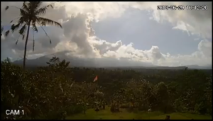
The current appearance of Mount Agung (June 29, 2018) is seen from the village of Redang, Karangasem. – source: channel telkomsel balinustra
DENPASAR – Continuous blowing in Mount Agung that issued smoke and volcanic ash since 28/6/2018 at 10.30 WITA until 29/6/2018 early morning has caused ash rains in the west to southwest. Himawari satellite data from BMKG show volcanic ash has covered the air space coordinates International Airport I Gusti Ngurah Rai.
Based on the official release of Head of Information Data and Public Relations of BNPB, Sutopo Purwo Nugroho received by Tribun Bali, said based on Coordination Meeting of Mount Agung Impact Impact Management on flight operation at Airport I Gusti Ngurah Rai on 29/6/2018 at 00.05 WITA decided Closing Airport (Closed Aerodrome) is recommended from 29/6/2018 at 03.00 WITA to 19.00 WITA. For the next issue NOTAM. Evaluation will be held again 29/6/2018 at 12.00 WITA.
The closure of the airport is related to the main safety. Some operators have made the decision to cancel flight with safety reasons.
For flight canceled flight on 28/6/2018, for 48 departures and arrivals with 8,334 passengers, the international flight is 38 flight with 6,611 passengers and 10 flight with 1,723 passengers.
Airlines that cancel flights are Air Asia, Jet Star, Qantas, and Virgin.
Meanwhile, the results of visual monitoring at Gunung Agung Observation Post PVMBG in Rendang, until Friday 29/6/2018 at 06.00 WITA, Mount Agung still issued volcanic ash and crater flame reddish color with stable intensity with a height of ash column reaches 2,500 meters.
Status is still Standby (Level 3). No status increases yet. It can not be estimated until how long the duration of effusive.
Currently microtremor is still detected on the seismograph tool PVMBG which indicates the movement of magma to the surface.
Seismic observed rapid increase of seismic amplitude within the last 12 hours.
Earthquakes are dominated by earthquakes with low frequency content manifested on the surface with gusts emitting gas and volcanic ash.
Ash rain occurs in some areas in the west and southwest of Mount Agung.
Areas exposed to ash temporarily occur in the Purage, Pempatan Rendang, Keladian, Besakih, Br. Beluhu, Suter Village because the dominant wind and ash leads to the west.
Deformation observed inflation since May 13, 2018 to date with an uplift of about 5 mm. This indicates the still development of pressure by magma in the body of Mount Agung.
Until now, the inflation of Mount Agung’s body still has not decreased.
The dangerous radius remains within a radius of 4 km from the top of the crater. The people living on the slopes of Gunung Agung conduct an independent evacuation.
As many as 309 people displaced in three dots of refugees in Tegeh Village, Amerta Bhuana Village, Banjar Dinas Galih Desa Jungutan and Banjar Village Village Village Village in Karangasem regency.
People are encouraged to remain calm. BNPB continues to coordinate with the Ministry of Transportation, PVMBG, BMKG, BPBD, Pemda Bali, and others. (*)
———
Sources: http://bali.tribunnews.com/2018/06/29/embusan-gunung-agung-menerus- remove-ash-volcanic-airport-ngurah-rai-closed-temporary? page = all
Translated by Aryaputra Pande– BIC

Be the first to comment.